-
 Forecasters say Hurricane Laura is rapidly intensifying and will become a “catastrophic” Category 4 hurricane before landfall. It's churning toward Texas…
 -
 ARZ050-051-059>061-070>073-LAZ001>006-010>014-017>022-OKZ077-TXZ096-097-108>112-124>126-136>138-149>153-165>167-270600-Hurricane Laura Local Statement…
 -
 BULLETIN Post-Tropical Cyclone Marco Advisory Number 21 NWS National Hurricane Center Miami FL AL142020 400 AM CDT Tue Aug 25 2020 ...MARCO BECOMES A…
 -
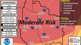
 Severe thunderstorms are expected to develop late this afternoon through the evening across much of the region. Large hail, damaging winds, and isolated…
 -
 Forecasters are warning of hurricane-force wind gusts and hail across the region as a potent storm threatens to spin up tornadoes and drench Louisiana and…
 -
 STATE AGENCY UPDATESLouisiana National GuardNearly 3,000 Louisiana National Guard soldiers remain deployed around the state and ready to assist in…
 -
 The National Weather Service has 3 damage survey teams out in the field today. They will be working to assess the damage from last night's storms and…
 -
 It’s a grim scene in Ruston today. A tornado hit the city around 2:15 a.m. causing widespread damage. According to initial reports, the storm caused two…
 -
 ...FLASH FLOOD WATCH NOW IN EFFECT UNTIL NOON CDT TODAY...The Flash Flood Watch is now in effect for* Portions of Arkansas, Louisiana, and east Texas,…
 -
 In anticipation of predicted heavy rainfall over the new several days, the City of Monroe Public Works Department is urging residents to ensure that all…

© 2024 KEDM

NPR News, Classical and Music of the Delta
Play Live Radio
Next Up:
0:00
0:00
Available On Air Stations


