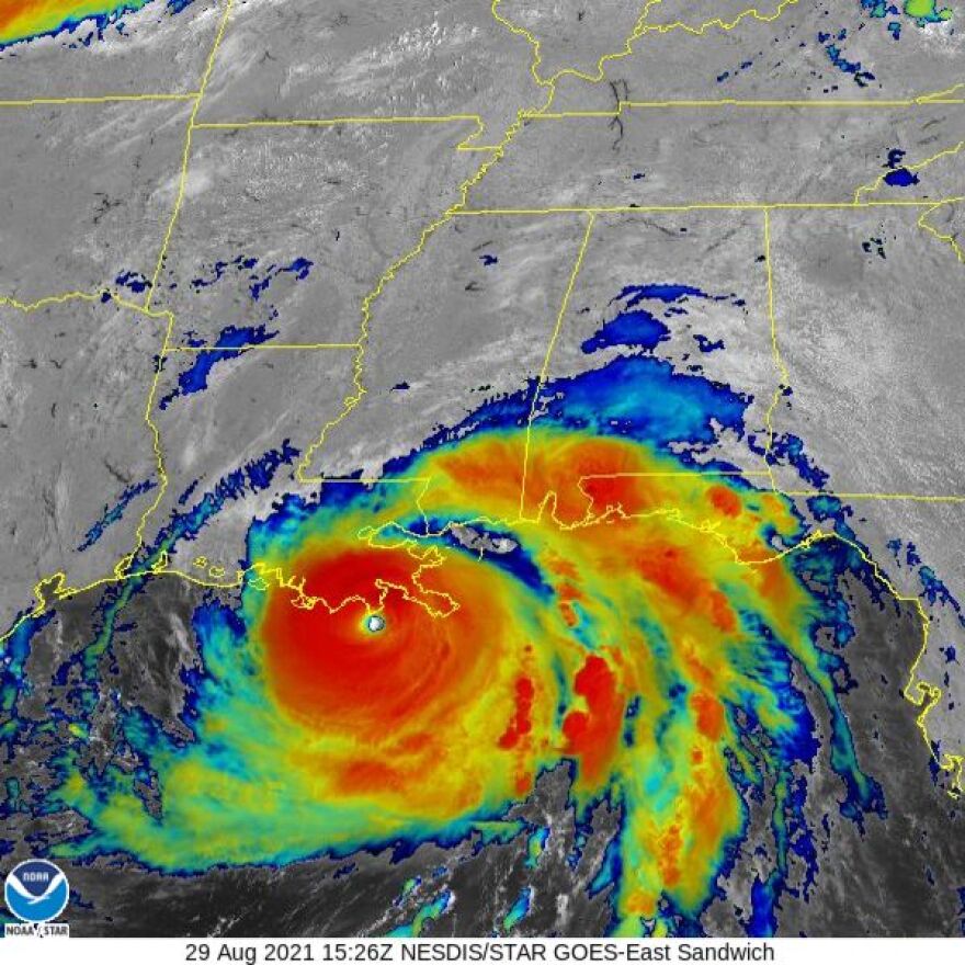
Hurricane Ida Local Statement Advisory Number 14
National Weather Service Shreveport LA AL092021
1026 AM CDT Sun Aug 29 2021
This product covers the ArkLaTex
**EYE OF EXTREMELY DANGEROUS CATEGORY 4 HURRICANE IDA NEARING THE
SOUTHEASTERN COAST OF LOUISIANA**
NEW INFORMATION
---------------
* CHANGES TO WATCHES AND WARNINGS:
- The Tropical Storm Warning has been cancelled for Natchitoches
* CURRENT WATCHES AND WARNINGS:
- A Tropical Storm Warning is in effect for Caldwell, Grant,
Jackson, La Salle, Ouachita, and Winn
 A Tropical Storm Warning is in effect for Caldwell, Grant, Jackson, La Salle, Ouachita, and Winn
* STORM INFORMATION:
- About 280 miles south-southeast of Monroe LA
- 28.8N 90.0W
- Storm Intensity 150 mph
- Movement Northwest or 320 degrees at 13 mph
SITUATION OVERVIEW
------------------
Category 4 hurricane continues to move northwest. Ida is forecast
to make landfall on the South Central or Southeast Louisiana coast
early this afternoon and curve to the north, roughly following the
Mississippi River. Ida will weaken as it moves inland. Tropical
storm-force winds will be possible across portions of North Central
and Northeast Louisiana during the day on Monday, starting during the
early morning hours. In addition, rainfall amounts of up to three
inches could result in isolated flooding across portions of North
Central and Northeast Louisiana. A Flash Flood watch remains in effect
for Sunday night into Monday. Ida will continue to weaken and move
northeast of the area Monday night into early Tuesday morning allowing
for improved conditions areawide.
POTENTIAL IMPACTS
-----------------
* WIND:
Protect against hazardous wind having possible limited impacts across
North Central and Northeast Louisiana. Potential impacts in this area
include:
- Damage to porches, awnings, carports, sheds, and unanchored
manufactured and mobile homes. Unsecured lightweight objects
blown about.
- Many large tree limbs broken off. A few trees snapped or
uprooted, but with greater numbers in places where trees are
shallow rooted. Some fences and roadway signs blown over.
- A few roads impassable from debris, particularly within urban
or heavily wooded places. Hazardous driving conditions on
bridges and other elevated roadways.
- Scattered power and communications outages.
Elsewhere across ArkLaTex, little to no impact is anticipated.
* FLOODING RAIN:
Protect against locally hazardous rainfall flooding having possible
limited impacts across North Central and Northeast Louisiana.
Potential impacts include:
- Localized rainfall flooding may prompt a few evacuations.
- Rivers and tributaries may quickly rise with swifter currents.
Small streams, creeks, canals, bayous, and ditches may become
swollen and overflow in spots.
- Flood waters can enter a few structures, especially in usually
vulnerable spots. A few places where rapid ponding of water
occurs at underpasses, low-lying spots, and poor drainage
areas. Several storm drains and retention ponds become
near-full and begin to overflow. Some brief road and bridge
closures.
Elsewhere across ArkLaTex, little to no impact is anticipated.
PRECAUTIONARY/PREPAREDNESS ACTIONS
----------------------------------
* PREPAREDNESS INFORMATION:
Now is the time to complete all preparations to protect life and
property in accordance with your emergency plan. Ensure you are in a
safe location before the onset of strong winds or possible flooding.
If you are relocating to safe shelter, leave as early as possible.
Allow extra time to reach your destination. Some roads and bridges
will be closed once strong winds arrive. Check the latest weather
forecast before departing and drive with caution.
Keep cell phones well charged. Cell phone chargers for automobiles
can be helpful, but be aware of your risk for deadly carbon monoxide
poisoning if your car is left idling in a garage or other poorly
ventilated area.
If you are a visitor, be sure to know the name of the city or town in
which you are staying and the name of the county or parish in which
it resides. Listen for these locations in local news updates. Pay
attention for instructions from local authorities.
Rapidly rising flood waters are deadly. If you are in a flood-prone
area, consider moving to higher ground. Never drive through a flooded
roadway. Remember, turn around don't drown!
Closely monitor weather.gov, NOAA Weather radio or local news outlets
for official storm information. Be ready to adapt to possible changes
to the forecast. Ensure you have multiple ways to receive weather
warnings.
* ADDITIONAL SOURCES OF INFORMATION:
- For information on appropriate preparations see ready.gov
- For information on creating an emergency plan see getagameplan.org
- For additional disaster preparedness information see redcross.org
NEXT UPDATE
-----------
The next local statement will be issued by the National Weather
Service in Shreveport LA around 4 PM CDT, or sooner if conditions
warrant.


